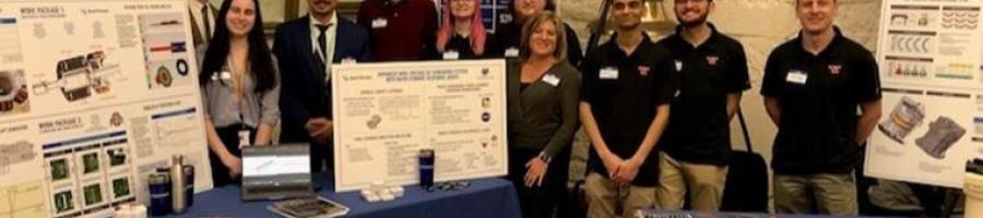
When FlightProfiler, Ohio University, and Ohio State University’s Center for Design and Manufacturing Excellence teamed up under the Ohio Federal Research Network Round 5 project, they shared a simple premise: pilots and drone operators urgently need better access to real-time, local, low-altitude weather data, especially visibility, the only meteorological factor directly covered to FAA flight rules. What began as a research concept has now become a commercial product available to anyone for $9.99, anywhere. On Apple and Android devices, the Visibility Tool mobile app transforms a smartphone into a trusted aviation visibility sensor.
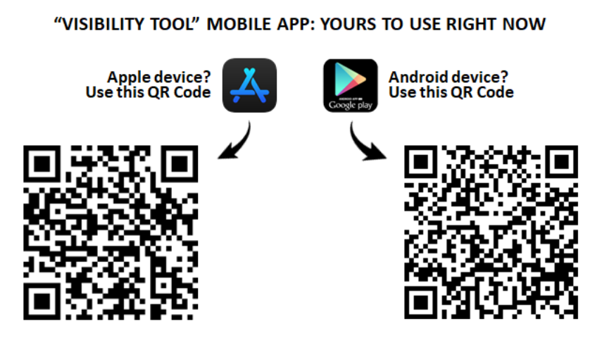
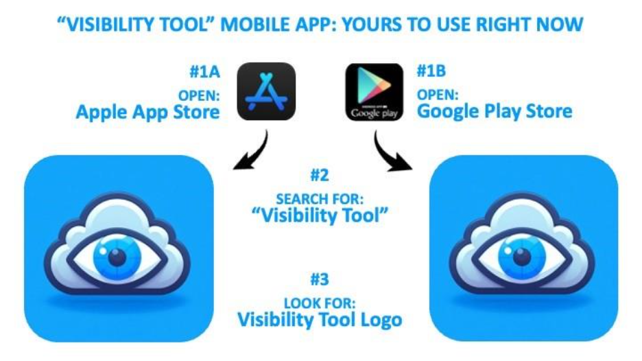
Discovering the technology can be accomplished via either of the following paths:
With the support and flexibility of the Ohio Federal Research Network (OFRN), the FlightProfiler team navigated multiple pivots—ultimately producing a breakthrough capability for general aviation pilots, drone operators, and the emerging AAM ecosystem.
A Problem Hidden in Plain Sight: Weather Data Gaps Below 5,000 Feet
Today’s national weather infrastructure includes only ~1,600 certified AWOS/ASOS and FAA weather camera sites across the entire United States, far too sparse to support the demand for drone, UAS, eVTOL, AAM and small-aircraft weather awareness. Pilots routinely fly in areas where no certified visibility information exists, forcing them to rely on estimates rather than data.
Visual Flight Rules (VFR) are fundamental to how the entire low-altitude aviation "see-and-avoid" regulatory structure is built,” said Ethan Krimins, President of FlightProfiler. “If visibility drops below minimums, see-and-avoid is no longer feasible.”
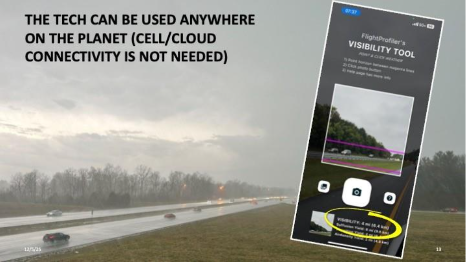
Visibility Tool closes this safety-critical gap by providing mobile, instantaneous, accurate visibility readings for anyone with a smartphone, even without cell service.

OFRN’s Support: Flexibility That Enabled Breakthrough Innovation
One of the most important enablers, Krimins says, was OFRN’s leadership and patience as the team iterated toward the right solution.
“Our team’s first swing at bat wouldn’t have connected,” he said. “OFRN gave us the room to pivot—multiple times—until we found the Visibility Tool Technology evolved into what customers wanted.”
Through OFRN funding, the team hired software developers and optical engineers from partner universities, refined the algorithms, and tested the technology across heterogeneous phone cameras, an effort that ultimately took more than two years.
This support positioned the tool for true transition: from concept to design to prototype to refinement to commercial production.
Now on the App Store: A First-of-Its-Kind Capability
After completing technical validation across different mobile devices, the FlightProfiler Team navigated Apple and Google’s approval processes, including privacy policies, regulatory compliance documentation, as well as application evaluation. In late 2025, Visibility Tool officially launched.
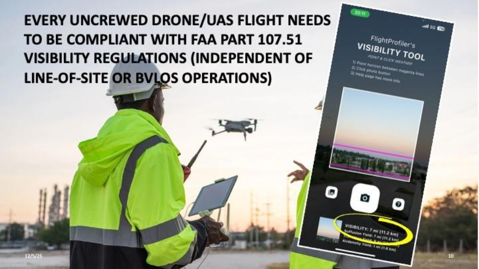
Users simply point their phone at the horizon, click once, and receive a visibility measurement which can be utilized for pre-flight planning and/or go/no-go decision making.
Technology benefits include:
Accurate visibility readings for aircraft operations
No reliance on distant weather stations
Offline functionality
Major Commercial Validation: Sporty’s 200,000+ Member Rollout
A key milestone came when Sporty’s Pilot Shop, the world’s largest pilot shop, committed to rolling Visibility Tool out to its 200,000+ newsletter members.
“Sporty’s is the pinnacle technology organization for all things aviation,” Krimins said. “You couldn’t ask for a better industry partner.”
This partnership signals widespread market acceptance and positions Ohio-developed technology to scale nationally.
“This is exactly the kind of practical innovation Sporty’s loves to champion,” said John Zimmerman, President, Sporty’s Pilot Shop. “The Visibility Tool puts powerful situational awareness in the palm of a pilot’s hand, and we’re proud to help bring this Ohio-developed technology to cockpits across the country.”
Expanding Markets: Drones, Logistics, and Advanced Mobility
The Visibility Tool is already gaining traction in general aviation, but its next wave of adopters includes:
Drone operators governed by FAA Part 107.51 visibility requirements
Commercial UAS fleets
eVTOL and AAM operators
State and municipal agencies
First responders, Medevac and emergency response organizations
Law enforcement
All share the same challenge: operations in the lower atmosphere with no guarantee of on-site weather sensors. Visibility Tool fills that gap.
Built in Ohio. Creating Jobs in Ohio.
As commercialization accelerates, FlightProfiler anticipates hiring workforce talent in:
Meteorological aviation software development
AI-driven sensing and analysis
Career seekers can follow FlightProfiler job ads here.
This aligns directly with OFRN’s mission to grow Ohio’s high-skill technical workforce through applied research.
“This success story demonstrates how OFRN-funded research drives both technological innovation and economic growth for Ohio,” said Maj. Gen. (Ret.) Mark Bartman, Executive Director, Ohio Federal Research Network. “The Visibility Tool not only enhances aviation safety nationwide, but it is also creating high-skilled jobs here in Ohio and opening new pathways for commercialization in emerging aerospace markets.”

A Platform for Growth: What Comes Next
The FlightProfiler team is not resting. On-going improvements include:
Increasing measurement accuracy
Developing additional low-altitude weather tools
Expanding capabilities for integration with UAS and AAM platforms
Krimins envisions a future where every drone pilot takes a visibility snapshot before flight, a simple pre-flight action that dramatically improves safety and compliance.
OFRN-Funded Research, Fully Commercialized
Commercializing new technology, especially in aviation, is notoriously difficult.
“Taking an idea and getting someone to buy it, is brutally hard,” said Krimins. “But with OFRN, we made it from idea to prototype to product generating revenue.”
The Visibility Tool stands as a model of successful technology transition, turning state-funded research into a commercial asset that strengthens safety, compliance, and national leadership in aviation innovation.
###
About Parallax Advanced Research & Ohio Aerospace Institute
Parallax Advanced Research is a research institute that tackles global challenges through strategic partnerships with government, industry, and academia. It accelerates innovation, addresses critical global issues, and develops groundbreaking ideas with its partners. With offices in Ohio and Virginia, Parallax aims to deliver new solutions and speed them to market. In 2023, Parallax and the Ohio Aerospace Institute (OAI) formed a collaborative affiliation to drive innovation and technological advancements in Ohio and for the Nation. OAI plays a pivotal role in advancing the aerospace industry in Ohio and the nation by fostering collaborations between universities, aerospace industries, and government organizations and managing aerospace research, education, and workforce development projects.
About the Ohio Federal Research Network
The Ohio Federal Research Network has the mission to stimulate Ohio’s innovation economy by building statewide university-industry research collaborations that meet the requirements of Ohio’s federal laboratories, resulting in the creation of technologies that drive job growth for the State of Ohio. The OFRN is a program managed by Parallax Advanced Research in collaboration with The Ohio State University and is funded by the Ohio Department of Higher Education.
About FlightProfiler
Since 2006, FlightProfiler has designed, developed and delivered aviation technologies, many of which are meteorological focused. The company invests heavily in R&D, collaborates with FAA, federal & academic institutions, and employs a world-class team of technologists.